Knowledge journal / Edition 1 / 2023
Marker Wadden: lessons from five years of applied research on building with mud and ecology
Between 2016 and 2022 the Marker Wadden were constructed with sand, clay and mud from Lake Markermeer, in the form of seven artificial islands. The goal was to create bird habitat and gradients between deep and shallow waters and dry zones. Moreover, Marker Wadden is intended to reduce the turbidity of Lake Markermeer by sheltering and the capture of mud, thus promoting the ecological development of the lake. The developments in the first five years were followed intensively. In this article we discuss ‘building with mud’ and the development of new nature.
The Marker Wadden are 1300 hectares in size and the distance from north to south is around 4 kilometres. The Wadden are a combination of seven islands with shallow water between them, in an environment that is 4 to 5 metres deep. The islands are built by filling compartments within raised sand ring dykes with soft mud. The sand and clay are extracted from the immediate environment of the islands in sand extraction pits and a mud trap dug for that purpose. On its extraction and transportation, the clay from these pits is mixed with water and pumped into the compartments at a low bulk density (approx. 1200 kg/m3).
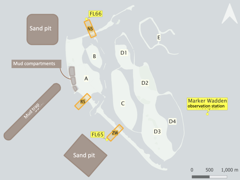 Figure 1. Marker Wadden with mud compartments, regular compartments A - E, a mud trap and sand extraction pits (source: KIMA synthesis report. Together, A and B form the freely accessible main island. C, D1, D2 and D3/4 are four non-accessible nature islands. The two E-islands have not yet been completed here.
The programme KIMA [Marker Wadden knowledge and innovation programme], completed in 2022, followed the project’s development. Diverse partners collaborate within KIMA, including WUR, Deltares, NIOO, RWS, Arcadis, Witteveen+Bos and several independent researchers. The results are summarised in a synthesis report (De Rijk & Löffler 2022). In this article, we present a selection of the results in respect of the building with mud and ecology components.
Building with mud
They key question is how to reliably and affordably create a stable substrate for a nutrient-rich lake-marshland situation by using mud. To this end, particularly in the mud compartments (see illustration 1), the consolidation of the mud layer and the settlement of the subsoil were monitored for two years (2019-2021) (illustration 2). The development of the strength of the mud layer and crust formation in the top layer after drying out were also followed, and spatial gradients were mapped in the consolidation, settlement and sediment properties.
The consolidation in the first year is fast, much faster than the settlement of the subsoil. The consolidation in the second year is much slower, not much faster than the settlement of the subsoil.
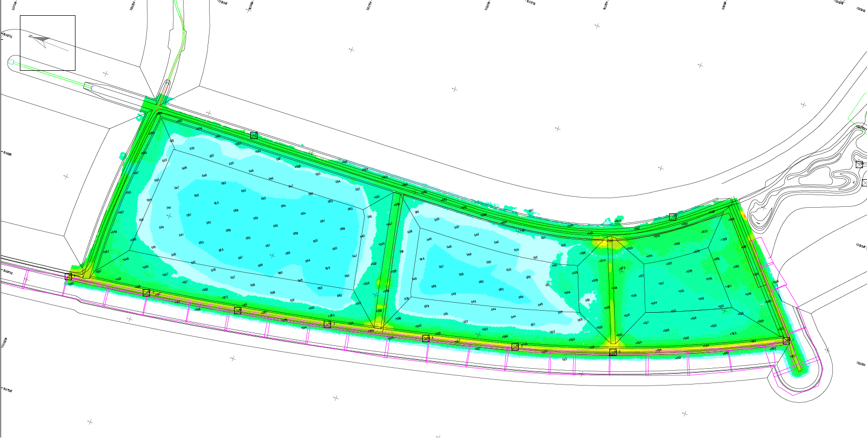 Figure 2. Elevation of the thin mud compartments, eleven months after the second filling (5 January 2021). Height in m NAP. Markermeer winter level between NAP -0.2 and -0.4 m; summer level between NAP -0.3 and -0.1 m.
The density of the mud package increases with time, but also varies spatially. Close to the filling point there is more sand and the density is higher. After two years, the maximum bulk density of silty deposits is approximately 1600 kg/m3 (975 kg of dry matter/m3) and then stops increasing. Compared to the bulk density during filling of approx. 1200 kg/m3 (325 kg dry matter/m3), this means that the mud volume has decreased by a factor of three, so per 3 m3 of pumped watery mud, 1 m3 of thickened mud is left. This is less than was expected beforehand based on small-scale experiments.
Water level management has a major influence on the process of consolidation and settlement, as it steers the thickness and surface of the crust. Strength develops quickly in this crust and provides sufficient bearing capacity for vegetation development.
This has led to the following conclusions on building with mud:
– The unmixing of sediment fractions during filling (by varying speeds of settlement) causes a spatial variation in the level and composition of the bottom, which is favourable for ecological diversity.
– After settlement and the draining of water, a crust forms which quickly gains strength. The consolidation of the layer of mud below largely takes place in the first few years. The settlement of the subsoil continues longer.
– Water level management is an important steering factor for crust-formation, consolidation and settlement and therefor also for vegetation development.
– The process of consolidation and settlement is easy to predict if the amount of mud and the sediment properties are known precisely. Because these are rather variable from one place to the next, model predictions are uncertain and the desired final level can be the most reliably realised by local ‘adjustments’ by means of extra mud.
Influence of the Marker Wadden on the mud fluxes in Lake Markermeer
The capture of the mud serves a double purpose: 1) the mud can be used for the Marker Wadden (man-made or naturally) and 2) a reduction of the turbidity of Lake Markermeer.
The mud dynamics in Lake Markermeer are strongly governed by the wind and are very variable. A combination of measuring and modelling has therefore been used to determine the effect of the Marker Wadden.
Illustration 3 shows the change determined in the mud concentration in the water column (left) and the amount of mud at the bottom (right). In the shelter of the islands, the mud concentration decreases. There and in the pits, a few decimetres and a few centimetres of mud per year respectively are deposited. On the scale of the entire Markermeer, this means a small but permanent effect (approx. 1-2 mg/l decrease). The mud deposited in the mud trench and the pits can be used for maintenance, i.e. to compensate residual settlement.
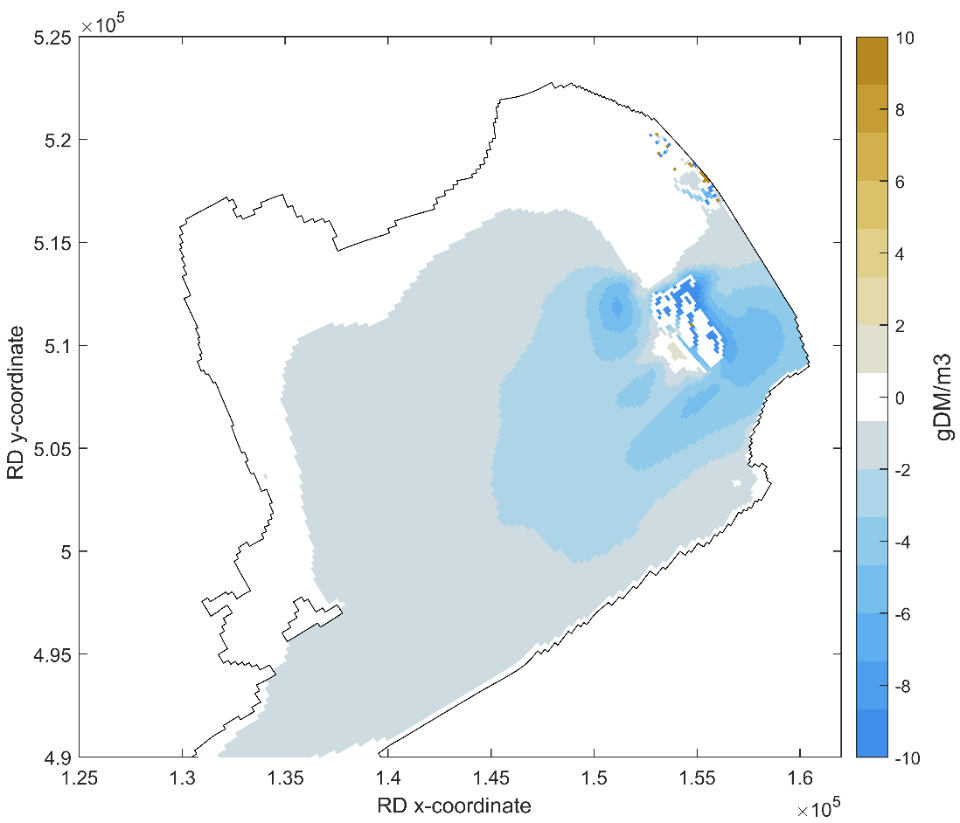
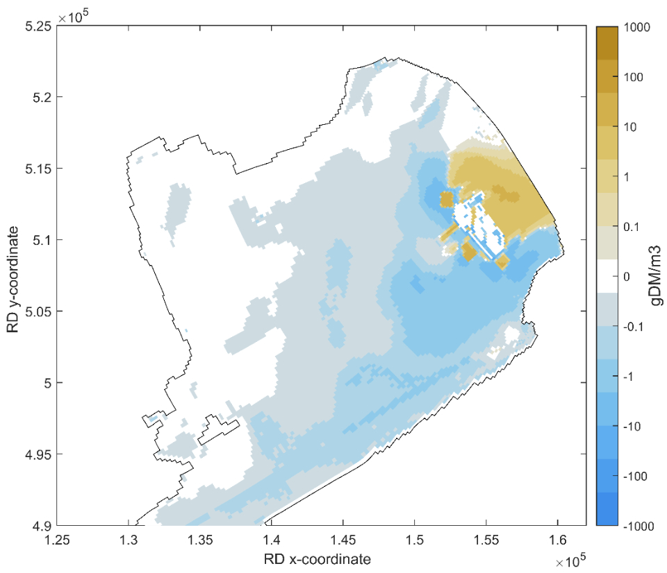 Figure 3. The influence of the Marker Wadden on the mud dynamics in Lake Markermeer. Top: reduction of mud concentration in water column. Bottom: change of the amount of mud at the bottom.
Ecology
The key issue in terms of ecology was how a nutrient-rich marshland with corresponding shallows and bank areas can develop and be sustainably maintained as a functional part of the Lake Markermeer ecosystem.
Building with nutrient-rich holocene clay has directly ensured high biological production and fast germination and growth of vegetation. In the past years there was a pioneer situation, with a nutrient-rich reed marsh gradually developing on the islands. The first thing to arise on a large scale was pioneer vegetation, especially including marsh fleawort and red goosefoot on the shallow mudflats and land-water transitions (illustration 4a). In addition, cattail and reed began to grow, whether or not aided by the contribution of seeds or rhizomes, as well as protection against overeating by geese. In this way new habitats have developed with a mosaic of shallows, gradual land-water transitions, mudflats and higher sandy parts. In shallow water, submerged vegetation gradually grew, including pondweed and stoneworts, with a spatial variation in species composition and structure (Illustration 4b). In the water bottoms, communities of benthic fauna arose. The shallow zones in the shelter of the islands with a rich structure and benthic fauna quickly provided an attractive habitat for many species of fish, at least 14 of which used the area as very suitable spawning and breeding grounds (De Leeuw et al. 2021).
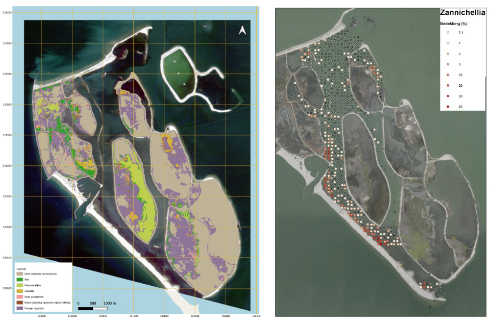 Figure 4: Vegetation and habitat development on and between the islands. Left: vegetation charting of the dry parts of the Marker Wadden in 2021. Light brown = bare muddy areas, light green = marsh fleawort, dark green = reed, orange = cattail, purple = other species (Klein Schaarsberg & Ivushkin 2021). Right: example of the presence of an aquatic plant species, the species Zannichellia in the trenches between the islands in 2021. From white to red in increasing density (Kers & Zielman 2022).
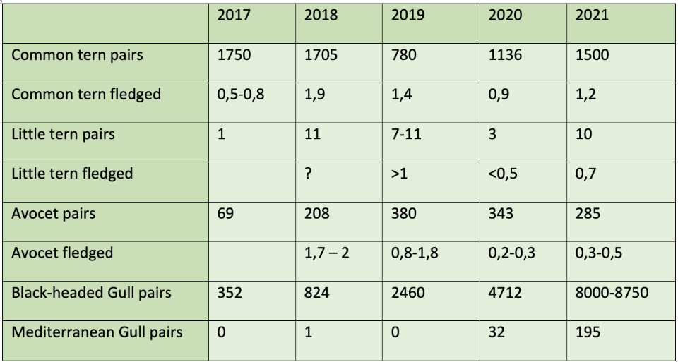
High densities of plankton, insects, benthic fauna and young fish are food for larger fish and local breeding birds. From the beginning, colonies of black-headed gulls and common terns settled on the sandy heights and dykes of the compartments, and numerous birds – particularly ducks and waders – found their way to the muddy compartments. In 2021, the total number of breeding bird pairs had increased to around 10,000, divided over almost 50 species. While in the first years the pioneer species of bare soils such as common terns, plovers and avocets were dominant (see the table), in recent years, marsh birds such as bearded reedlings, sedge warblers and water-rails are making their presence felt. Moreover, tens of thousands of birds make use of the islands while migrating or in the winter as foraging and sleeping areas. The birds use the Marker Wadden on a landscape scale, meaning that there is lots of exchange with surrounding areas such as the Oostvaardersplassen and Trintelzand, and that the areas strengthen each other.
The islands also influence the ecology of Lake Markermeer as a whole. The most obvious effect is the addition of habitats and species that were underrepresented as a result of the unnatural depth distribution of the lake by the steep stone banks. Rich habitats such as marshland, mudflats, shallows with aquatic plant species and gradual land-water transitions come about. In these habitats, benthic fauna develops well, and in turn are a major source of nutrition for fish and birds.
The intended positive effect on the food web and the productivity by the improvement of the water quality around the Marker Wadden is less evident, but the work has only just been completed. In the shelter of the islands, new gradients of clear to turbid water arise, in combination with spatially varied patterns of erosion and sedimentation (illustrations 3 and 5). This is favourable for the functioning of the entire ecosystem of Lake Markermeer. Large numbers of fish can gather in the mud traps.
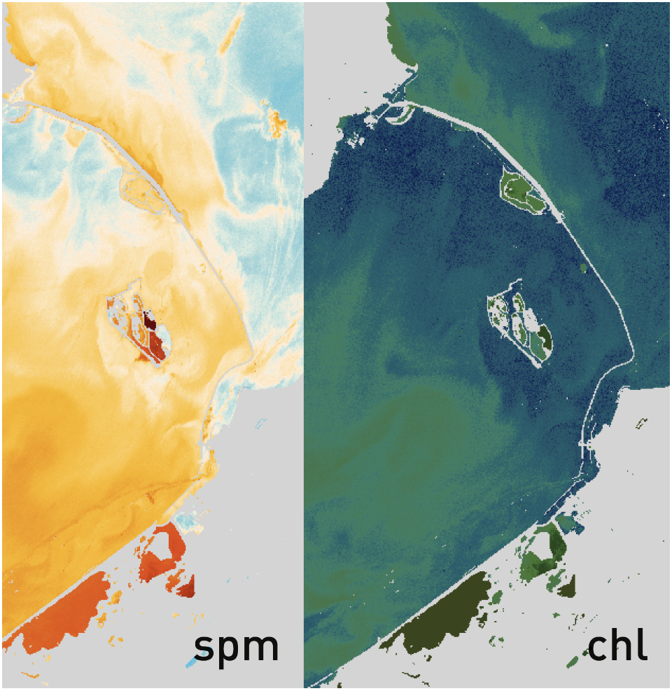 Figure 5. Shelter to the south of the Marker Wadden with wind from the north, 13 May 2019, with the Marker Wadden in the centre of the images. Sentinel satellite image, processed for suspended material (spm) and chlorophyl (chl). The images show reduced concentrations of suspended material (light colour) and chlorophyll (dark colour) (De Rijk & Löffler 2022).
Table 1. Numbers of breeding pairs of gulls, sterns and avocets on the Marker Wadden and the average number of young birds that have fledged per pair (including Dreef et al. 2021; for other sources see De Rijk & Löffler 2022).
What does this mean in practice?
The first five years of the Marker Wadden show that the higher sandy edges provide stability in the archipelago, and breeding grounds for birdlife. The dynamic wetlands with lake-marshland mudflats on nutrient-rich soil ensure high food production, thus forming an ideal foraging area for many birds and a breeding ground for fish. Through connections between the compartments and the surrounding water via trenches and wash-overs, dynamics of water and sediment flows arise between the shallows between the islands and Lake Markermeer.
The results to date also show that ecological development in the mud-built marshland is coming along well. Especially for birds, high natural values have been achieved, which are of national or even international significance in the light of Natura 2000. These developments also signify a major enrichment of the Markermeer ecosystem.
The fact that the vegetation is an early state of succession however, means that the current state of nature there is temporary. The high nature values are partly related to the scarce pioneer situations, which rare species can only make temporary use of. Upon further succession, new habitats arise, in turn offering opportunities for other species. Future developments are uncertain. It is clear, however, that dynamism is required for the sustainable presence of reed marsh and functional land-water interactions, either in the form of water motion (water-level fluctuations), or by specific management. The natural dynamics in Lake Markermeer are restricted by the use of a fixed target water level. This also limits the exchange of nutrients between the Marker Wadden and the lake. As long as the quays of the compartments have not yet been opened, in principle, the compartments can manage their own water level. By (permanently) opening compartments at a specific moment, the exchange of water, mud, nutrients, fish, etc. between Lake Markermeer and the Marker Wadden is possible, whereby the timing of the opening is important for the balance between the consolidation, erosion and sedimentation of mud and the influence of vegetation. Wash-overs in the edges (constructed lowerings) of the compartments form an intermediate solution.
The construction of the islands has also impacted the physical environment. In the sand extraction pits and the shelter of the islands, for instance (with gradients of turbid to clear water) new habitats have arisen for fish, birds and benthic fauna, for instance. However, part of the nutrients from the lake and swamp appear to accumulate in deep pits in the environment of the islands, which could possibly negatively affect the exchange between both sub-systems. This is one of the subjects for a follow-up study in KIMA-2.
Ruurd Noordhuis
(Deltares)
Thijs van Kessel
(Deltares)
Joep de Leeuw
(WUR - Wageningen Environmental Research)
Summary
After five years of research on the Marker Wadden there is now a first overview of the results. This article discusses two aspects: building with mud and the ecology. The construction of the islands with mud from Lake Markermeer took place as scheduled, although the settlement of the mud layer was stronger than expected. In the shelter of the islands and the sand extraction pits, the mud concentration decreases. This means a small but permanent reduction of the turbidity of the whole Markermeer.
The ecological development in the constructed swamps is well underway, which is especially apparent from the abundance of birdlife. In the sand extraction pits and the shelter of the islands, new habitats arise for fish, birds and benthic fauna. This is a major enrichment of the Markermeer ecosystem. The succession continues, meaning that some nature values will turn out to be temporary.
Sources
De Rijk S. & M. Löffler. 2022. SyntheserapportKIMA. De eerste vijf jaar onderzoekop Marker Wadden. Deltares,Utrecht. [KIMA Synthesis report. The first five years’ research on Marker Wadden. Deltares, Utrecht].
De Leeuw, J.J., J. Volwater, O. van Keeken, J. Elings & C. van Leeuwen, 2021. Paai- en opgroeigebieden voor vis in en rond Marker Wadden [Spawning and breeding areas for fish in and around Marker Wadden]. Wageningen Marine Research report C058/21
Dreef, C., J. van der Winden & Y.I. Verkuil. 2021. Broedvogels en pleisteraars op Marker Wadden 2020-2021 [Breeding birds and plasterers at Marker Wadden 2020-2021]. Report 2021-02, Camilla Dreef, Amsterdam.
Kers A.S. & J. Zielman 2022. Toelichting bij de Waterplantenkartering Marker Wadden 2021. [clarification for the charting of aquatic water species in the Marker Wadden 2021]. Rijkswaterstaat, CIV, Delft.
Klein Schaarsberg F.L.H. , and K. Ivushkin, 2021. Monitoring vegetatie ontwikkeling op land. Rapportage t.b.v project WN08 2019 Marker Wadden -Remote Sensing [Monitoring vegetation development on land. Report for project WN08 2019 Marker Wadden -Remote Sensing]. Witteveen + Bos, report 119777/21-017.059, Deventer.
Auteurs

Ruurd Noordhuis
(Deltares)
Thijs van Kessel
(Deltares)

Joep de Leeuw
(WUR - Wageningen Environmental Research)